
- Afhalen na 1 uur in een winkel met voorraad
- Gratis thuislevering in België vanaf € 30
- Ruim aanbod met 7 miljoen producten
- Afhalen na 1 uur in een winkel met voorraad
- Gratis thuislevering in België vanaf € 30
- Ruim aanbod met 7 miljoen producten


Omschrijving
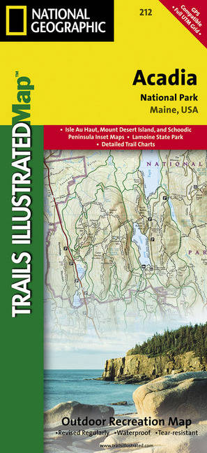
- Waterproof - Tear-Resistant - Topographic Map
National Geographic's Trails Illustrated map of Acadia National Park is designed to meet the needs of all visitors who wish to explore the islands and bodies of water of this national park. Expertly researched and created in partnership with the National Park Service and others, this map features over 120 miles of trails, ferry routes and key points interest. The print version of the map also includes insets of Mount Desert Island, Schoodic Peninsula and Isle Au Haut. The print and online maps both include trail charts for each of these 3 areas with area descriptions, distances, difficulty ratings and trail features to help you choose the trail most suitable for your activity level and areas of interest.
In addition to the unparalleled trail information, the map also covers the historic carriage road system that covers large parts of Mount Desert Island. The map base includes contour lines and elevations of the mountain and contours of all the rivers, lakes, sounds, ponds and other bodies of water that are within and surround the park. The map also display many recreational features and other points of interest, including: visitor centers, campgrounds, trailheads, boat ramps, interpretive trails, swimming areas, museums, lighthouses and ferry launch points.
Every Trails Illustrated map is printed on "Backcountry Tough" waterproof, tear-resistant paper. A full UTM grid is printed on the map to aid with GPS navigation.
Other features found on this map include: Acadia, Blue Hill Bay, Cadillac Mountain, Deer Isle, Frenchman Bay, Isle Au Haut, Mount Desert Island, Schoodic Peninsula, Swans Island.
- Map Scale = 1:35,000
- Sheet Size = 25.5" x 37.75"
- Folded Size = 4.25" x 9.25"
Specificaties
Betrokkenen
- Auteur(s):
- Uitgeverij:
Inhoud
- Aantal bladzijden:
- 2
- Taal:
- Engels
- Reeks:
Eigenschappen
- Productcode (EAN):
- 9781566953528
- Verschijningsdatum:
- 1/10/2017
- Uitvoering:
- Gevouwen kaart
- Bestandsformaat:
- Gelamineerd
- Afmetingen:
- 10 cm x 19 cm
- Gewicht:
- 43 g


Alleen bij Standaard Boekhandel
+ 31 punten op je klantenkaart van Standaard Boekhandel
MUST-HAVES

AANGERADEN

MOEDERDAG ACTIE


Beoordelingen
We publiceren alleen reviews die voldoen aan de voorwaarden voor reviews. Bekijk onze voorwaarden voor reviews.